About Dolores and McElmo Basins
The Dolores River flows directly to the Colorado River upstream of Lake Powell. The McElmo Creek basin is adjacent to the Dolores River but flows to the San Juan River, which then flows into Lake Powell. Diversions from the Dolores River into the McElmo Basin began in the 1880s and increased with construction of the Dolores Project completed in 1999. Water diverted from the Dolores Project irrigates more than 60,000 acres in the McElmo Basin. Diversions from the Dolores River now occur at McPhee Reservoir just downstream of the Town of Dolores. Below McPhee Reservoir irrigation occurs along the Dolores River in rural communities surrounding Bedrock, Slickrock, and Paradox as well as other portions of San Miguel and Montrose counties.
The Dolores Project supplies water for Ute Mountain Ute Indian Tribe irrigation and for full-service irrigators along the Dove Creek Canal and provides a supplemental supply to Montezuma Valley Irrigation Company. The Project also provides municipal water to the City of Cortez, the Town of Dove Creek, and the Town of Towaoc on the Ute Mountain Ute Reservation.
As part of the Colorado River Basin Salinity Control Act, the Paradox Valley Unit was constructed along the Dolores River in western Montrose County. This PVU extracts naturally occurring brine groundwater in the Paradox Valley which prevents it from entering the Dolores River. Since 1996 approximately 100,000 tons of salt was injected annually resulting in 10 percent decrease in overall salinity in the Colorado River. The PVU operations have been suspended and/or injections rates decreased in recent years due to increased seismic activities. A 2020 Environmental Impact Statement recommend continued use of the PVU until it is no longer feasible to operate with no future salinity control planned in the Paradox Valley.
The Dolores Project also provides recreation on McPhee Reservoir, fishery releases below the reservoir, and when available makes spill releases to enhance boating through the Dolores Canyon below McPhee. Even though the San Miguel River is a tributary to the Dolores River, it is considered a separate basin in the Southwest Basin.
Dolores and McElmo Basins Projects Information
Use the following tabbed information to explore water project information addressing Dolores and McElmo Basins's water needs.
Sub Basin Map
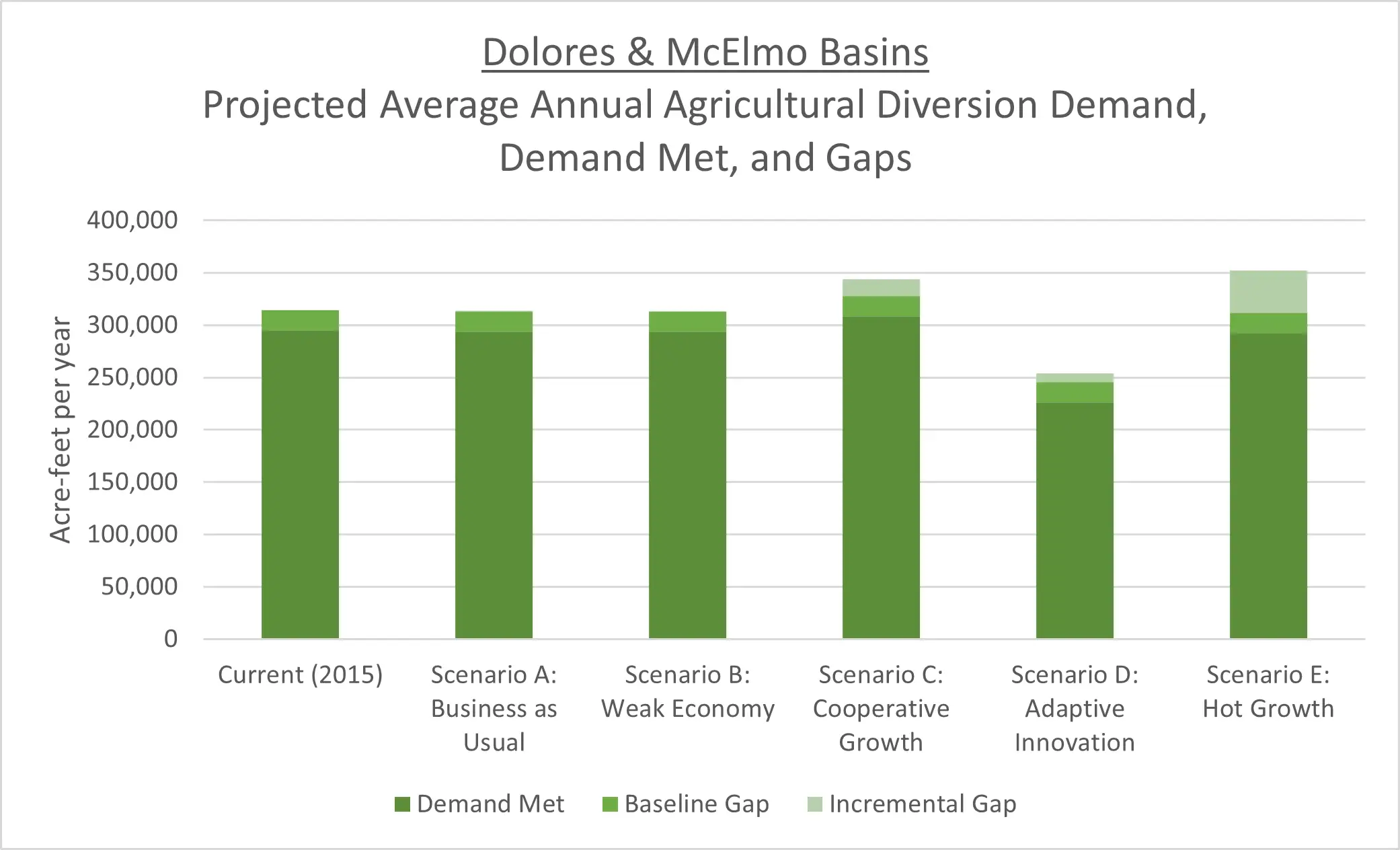
Demand, Supply, and Potential Water Needs
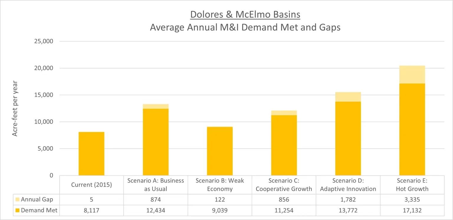
Municipal and Industrial Demand, Supply, and Potential Water Needs
The Technical Update to the Colorado Water Plan (Referred to herein as the Technical Update) estimated the population of the Southwest Basin to be about 2 percent of the statewide population, which was about 108,000 people in 2015. Population in the Southwest Basin is projected to grow to between 130,000 and 280,000 people between 2015 and 2050.
The Southwest Basin’s average 2015 Baseline per capita system demand is approximately 198 gallons per capita per day (gcpd). Sources of water demand data, such as Senate Bill 1051 or Municipal Water Efficiency Plans (WEP), made up 48 percent of available information (reference the Technical Update, Section 4.9.5 Municipal and Self-Supplied Industrial Diversion Demands, page 165).
The Southwest Basin’s municipal demands were approximately 24,000 acre-feet per year (AFY) in 2015, which is projected to increase to between 26,000 and 63,000 AFY in 2050. The Southwest Basin’s industrial demands are minimal, with a 2015 Baseline demand of 2,280 AFY, which also is projected to increase to between 3,940 to 4,720 AFY in 2050.
For a detailed explanation of the methodologies used for estimating municipal and industrial (M&I) demands and gaps, reference the Technical Update Volume 1, Section 2.2.4 M&I Demands. For further information about the Southwest Basin’s M&I demands, reference the 2021 BIP Volume 1.
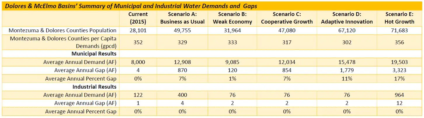
Dolores County, which encompasses large portions of the Dolores River, had a population of about 1,900 in 2015, which was about 2 percent of the total Southwest Basin’s population. This county’s population is expected to increase in four of the five planning scenarios, ranging from a decrease of 15 percent under Scenario B to a 90 percent increase under Scenario E.
Montezuma County, which encompasses the Mancos, McElmo, and portions of the Dolores rivers, had a population of about 26,100 in 2015, which was about 24 percent of the total Southwest Basin’s population. This county’s population is expected to increase in all planning scenarios, ranging from just 16 percent under Scenario B to a 160 percent increase under Scenario E.
Montezuma County accounts for just under one third of the Southwest 2015 Baseline demand. Municipal and domestic water are supplied by the City of Cortez, Town of Dove Creek, Town of Dolores, Town of Rico, the Montezuma Water Company, a few small domestic systems, and wells.
Montrose County, which encompasses portions of the San Miguel and Dolores rivers, had a population of about 4,000 in 2015 within the boundaries of these two watersheds, which was about 4 percent of the total Southwest Basin’s population. This county has a population in both the Southwest and Gunnison basins, with only a portion of the population attributed to the Southwest Basin. This county’s population is expected to increase in all planning scenarios, ranging from just 17 percent under Scenario B to a 163 percent increase under Scenario E.